How GNSS Multi-Frequency Improves Fleet Tracking
Multi-frequency GNSS delivers sub-metre accuracy, faster fixes, improved urban reliability and lower operating costs for fleets.

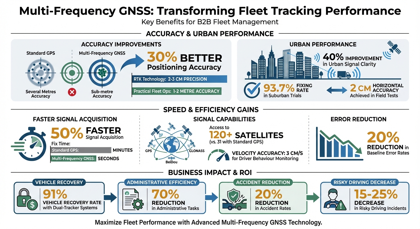
Fleet tracking has become far more accurate and reliable with GNSS multi-frequency technology. Unlike older single-frequency systems, this advanced approach uses multiple satellite signals (e.g., L1, L2, L5) to deliver sub-metre accuracy, faster signal lock times, and improved performance in urban areas.
Key benefits include:
- 30% better positioning accuracy and a 40% improvement in urban signal clarity.
- Faster signal acquisition - up to 50% quicker in challenging conditions.
- Reliable tracking in areas like tunnels or dense cities using signal redundancy and dead reckoning.
- Reduced fuel costs and better route planning with precise positioning.
Multi-frequency GNSS also supports UK-specific needs, like Galileo's high-latitude performance, ensuring uninterrupted tracking even in Scotland or northern England. For fleet operators, this means fewer delays, improved compliance, and cost savings. Whether managing a small van fleet or a large lorry operation, this technology is a practical upgrade for modern fleet management.
Multi-Frequency GNSS Benefits for Fleet Tracking: Key Performance Improvements
What is Multi-Band GNSS and Why Should You Care About It?
How Multi-Frequency GNSS Improves Tracking Accuracy
Multi-frequency GNSS has brought a new level of precision to fleet tracking solutions. By processing signals from multiple frequency bands - commonly L1 and L5 - receivers can measure ionospheric delays directly rather than relying on estimates. This reduces positioning errors from several metres down to sub-metre accuracy.
Centimetre-Level Accuracy
Real-Time Kinematic (RTK) technology takes accuracy even further by using the carrier phase and resolving the 'integer ambiguity', achieving pinpoint precision down to 2–3 centimetres. As Navixy explains:
"Dual-frequency GPS significantly boosts accuracy, enabling it to pinpoint specific lanes rather than just the road a vehicle is on." – Navixy
This means fleet managers can identify the exact lane a vehicle occupies. Additionally, multi-frequency systems reduce baseline error rates by approximately 20% and cut the time needed to acquire an accurate position fix from minutes to mere seconds.
Consistent Positioning in Urban Areas
Urban environments often pose challenges like multipath errors, where signals bounce off tall buildings, leading to inaccuracies. Multi-frequency systems tackle this issue by using the L5 band, which has a 10 MHz bandwidth and higher signal strength, allowing it to differentiate real signals from reflections. Field tests have demonstrated that this approach improves signal clarity by about 40% in densely built-up areas. In suburban trials, these systems achieved horizontal accuracy within 2 centimetres and maintained a fixing rate of 93.7%. For fleet operators in UK cities like Birmingham or Edinburgh, where traffic congestion and narrow streets complicate navigation, this technology provides more precise dispatching and arrival predictions. These capabilities are essential for various industry-specific van tracking requirements. Such advancements make navigating even the toughest urban environments more reliable.
Maintaining Reliability in Difficult Conditions
Fleet vehicles often encounter challenging environments like tunnels, industrial areas, and bustling city centres where satellite signals can be blocked or weakened. Multi-frequency GNSS technology tackles these obstacles by combining signal redundancy with dead-reckoning systems, ensuring uninterrupted tracking and navigation.
Signal Redundancy and Continuity
Multi-frequency GNSS receivers can simultaneously track multiple satellite constellations, including GPS, GLONASS, Galileo, and BeiDou. This capability allows the system to switch seamlessly between frequencies - such as from L2 to L1 or L5 - if one becomes blocked. As NovAtel explains:
"The ability of a GNSS receiver to handle multiple frequencies from multiple constellations in the calculation of position is essential to optimal error resolution." – NovAtel
This redundancy is especially useful in industrial settings where radio frequency interference is prevalent. Additionally, the L5 signal’s higher power enables better penetration through materials like concrete and dense foliage, making it more reliable in urban landscapes.
However, even with advanced signal redundancy, certain environments, such as tunnels, can completely block GNSS signals. That’s where dead-reckoning steps in to maintain positional accuracy.
Dead-Reckoning for Navigation Backup
In situations where vehicles enter tunnels or underground car parks, dead-reckoning technology uses onboard sensors to estimate the vehicle's position based on its last GNSS fix. Septentrio describes this process:
"A GNSS/INS system can use an inertial sensor to calculate relative position to the last known GNSS position, filling in the blanks during a temporary GNSS outage." – Septentrio
For fleets operating in UK cities, where tunnels and underpasses are common, this integration ensures uninterrupted location tracking. This is a critical feature for van tracker systems designed to operate in dense urban environments. Mathias Vetter, Principal Product Manager at u-blox, highlights the long-term benefits:
"In the long run, merging multi-band GNSS and dead reckoning will undoubtedly improve the reliability of GNSS positioning in our cities." – Mathias Vetter
Cost Benefits and Return on Investment
Multi-frequency GNSS doesn’t just improve accuracy and reliability - it also offers clear financial advantages. While the initial investment might seem significant, the long-term savings far outweigh the upfront costs. Fleet operators can benefit from reduced fuel usage, optimised routing, and a decreased risk of asset loss, including theft.
Lower Operating Costs
Better tracking systems mean less idling and fewer reroutes, directly cutting down on fuel expenses - an especially valuable benefit for fleets navigating the UK's busy city roads and motorways. With accurate positioning data, drivers avoid unnecessary delays, make fewer wrong turns, and complete their routes more efficiently.
Additionally, multi-frequency technology is more resilient against signal interference or jamming. Gianmarco Zanda from Telit Cinterion highlights this advantage:
"Using two frequencies allows devices to achieve greater location accuracy and be less affected by jamming or interference".
This resilience not only ensures smoother operations but also helps reduce costly downtime.
Affordable High-Accuracy Solutions
Another major perk is the ability to achieve high accuracy without investing in expensive infrastructure. With PPP (Precise Point Positioning), fleet managers can access centimetre-level precision without needing costly base stations. This means professional-grade tracking becomes accessible without the financial burden of maintaining additional equipment.
Modern multi-frequency chipsets also stand out for their energy efficiency. Features like adaptive power modes and cloud-based "snapshot positioning" significantly lower battery consumption in asset trackers, prolonging their lifespan. This efficiency reduces both downtime and replacement costs. For fleets managing hundreds of vehicles, these savings add up quickly. As Telit Cinterion puts it:
"Integrating multiple GNSS systems helps industries and businesses future-proof their products and services".
This ensures that your investment remains effective as satellite technology continues to evolve, offering both operational efficiency and meaningful cost savings.
For fleet operators eager to tap into these advantages, GRS Fleet Telematics offers van tracking solutions designed to meet the unique challenges of managing fleets in the UK.
How to Implement Multi-Frequency GNSS for Your Fleet
Switching from single-frequency to multi-frequency GNSS might sound complex, but it doesn’t have to be. The trick is to align your hardware and software choices with the specific needs of your fleet - whether you’re managing a handful of vans or a large fleet of lorries.
Hardware and Software Integration
Start by selecting hardware that supports at least two frequencies, such as L1 and L5 (or L1 and L2). These dual-band receivers can measure and correct ionospheric delays in real-time, boosting accuracy from several metres to sub-metre or even centimetre-level precision.
For urban environments where tall buildings block signals, ensure your devices can access multiple satellite systems like GPS, Galileo, BeiDou, and GLONASS. This improves signal reliability and positioning accuracy. If your fleet operates in areas prone to GNSS outages - like tunnels or multi-storey car parks - look for devices equipped with an Inertial Measurement Unit (IMU) for dead reckoning.
Modern chipsets from brands like MediaTek, Qualcomm, Broadcom, and u-Blox combine multi-band GNSS with BLE 5.x and 5G connectivity, offering cost-effective, all-in-one solutions. Leading telematics manufacturers such as Queclink, Teltonika, and Ruptela now include dual-band GNSS as a standard feature in their flagship models. For example, the Teltonika FMC880 comes with L1/L5 frequencies built-in.
On the software side, your platform should support correction techniques like Real-Time Kinematic (RTK) for centimetre-level accuracy or Precise Point Positioning (PPP) for broader coverage without the need for expensive base stations. Platforms like GRS Fleet Telematics integrate seamlessly with multi-frequency hardware, offering real-time tracking and automated compliance reporting starting at £7.99 per month.
By combining the right hardware and software, you can create a scalable solution that works for fleets of any size.
Scaling for Different Fleet Sizes
Scaling multi-frequency GNSS for fleets of varying sizes requires balancing precision, power consumption, and cost. The level of accuracy needed will differ depending on the type of vehicle or asset.
For small fleets (fewer than 20 vehicles), devices with adaptive power modes are ideal. These optimise power usage based on operating conditions. Adjust update rates to match operational needs: vehicles in motion may require updates every second, while stationary assets might only need updates once or twice a day.
Medium to large fleets can benefit from cloud-based processing. In this setup, the GNSS receiver captures signals, but complex calculations are handled in the cloud. This "snapshot positioning" reduces battery consumption across multiple devices. Including backup batteries in your hardware can also prevent "cold starts", which drain power and delay tracking.
Looking ahead, multi-frequency receivers are ready to support upcoming services like Galileo HAS for decimetre-level accuracy (approximately 20 cm) and OSNMA for anti-spoofing. These features ensure your hardware remains future-proof without needing replacement.
Once your hardware and software are scaled effectively, meeting UK fleet regulations becomes much simpler.
Meeting UK Fleet Regulations
With scalable hardware in place, the next step is ensuring compliance with UK fleet regulations. Multi-frequency GNSS offers improved accuracy and reliability, helping fleets meet strict requirements. Enhanced signal continuity ensures no gaps in compliance records, even in challenging urban areas, which improves route tracking and reduces downtime.
Make sure your hardware complies with the Radio Equipment Directive (RED), carries a CE mark, and meets ETSI EN 303 413 standards for efficient spectrum use. As ib-lenhardt explains:
"GNSS receivers are considered radio equipment under the Radio Equipment Directive (RED). No individual radio licence is required, but CE conformity is mandatory".
Hardware should also support the Galileo constellation, which is mandatory for European eCall systems and increasingly important for UK emergency services. Galileo’s 24+ satellites provide better positioning at higher latitudes, making it particularly useful for fleets operating in Scotland and northern England.
For drivers' hours compliance, implement systems that automatically log start and finish times, driving hours, and rest breaks. Multi-frequency GNSS ensures uninterrupted positioning in urban areas, maintaining accurate compliance records. Real-time alerts can notify drivers and managers when legal driving limits are nearing, such as the mandatory 45-minute break after four hours of driving.
To address data privacy and GDPR requirements, use robust encryption, strict access controls, and clear data processing agreements. Digitised, time-stamped logs create a tamper-proof audit trail for DVSA spot checks. Conduct Data Protection Impact Assessments (DPIAs) to safeguard sensitive driver location and performance data.
Switching to automated telematics can streamline operations significantly. For instance, automated records can cut administrative tasks by up to 70%, while telematics systems can reduce accident rates by up to 20% and minimise risky driving incidents by 15–25%.
Practical Applications and Results
Multi-frequency GNSS is reshaping fleet management in the UK, delivering measurable benefits across various practical scenarios. From cutting fuel expenses to improving vehicle recovery rates, this technology is redefining how businesses handle their fleets.
Better Dispatch and Route Planning
With positioning accuracy reaching 1–2 metres compared to the 5–10 metres of standard systems, dispatchers can assign drivers to jobs with far greater confidence and precision.
Another advantage lies in the use of multi-constellation receivers, which tap into signals from over 120 satellites, a significant leap from the 31 satellites typically available with standard GPS. This expanded satellite access is particularly valuable in urban environments where tall buildings can block parts of the sky. Even in these challenging conditions, the system ensures uninterrupted tracking.
Additionally, velocity accuracy down to 3 cm/s allows fleet managers to monitor driver behaviour closely, identifying patterns like idling or harsh acceleration. This level of detail not only helps refine fuel usage but also highlights areas for targeted driver training.
Driver Safety and Vehicle Recovery
Beyond optimising dispatch, multi-frequency GNSS significantly enhances safety and asset protection.
By utilising signal redundancy across frequencies like L1 and L5, the system ensures uninterrupted positioning, which is critical for real-time driver monitoring and theft recovery. Combined with geofencing alerts, this capability offers an extra layer of operational safety.
For stolen vehicle recovery, uninterrupted tracking proves invaluable. For example, GRS Fleet Telematics reports a 91% recovery rate by combining multi-frequency GNSS with dual-tracker technology. Their system includes a primary tracker for real-time updates and a secondary Bluetooth backup to prevent thieves from disabling the system. These solutions are accessible at prices starting from £35 for a single tracker or £79 for the enhanced dual-tracker option.
The inclusion of the European Galileo system adds further security benefits. Galileo facilitates two-way communication between satellites and ground stations, supporting search and rescue beacons. With real-time positioning accuracy of up to 1 metre, recovery teams can locate stolen vehicles more efficiently. Considering that around 8% of the European economy relies on GNSS, adopting multi-frequency technology is a smart move for businesses looking to ensure continuity in today's interconnected world.
Conclusion
Throughout this guide, we've explored how multi-frequency GNSS can bring a new level of precision and reliability to UK fleet operations. By addressing ionospheric delays and minimising multipath errors, these systems achieve centimetre-level accuracy and deliver around 40% better signal clarity in congested urban areas compared to single-frequency setups.
For fleet managers, this means better route planning, improved fuel efficiency, and greater oversight of driver activity, all contributing to smoother and more productive operations. The technology also drastically reduces fix times - from minutes to just seconds - ensuring drivers stay on track and on time.
When vehicle security is a concern, multi-frequency GNSS steps up with strong jamming resistance and signal redundancy, making it much harder for thieves to interfere with tracking systems. Combine this with dual-tracker solutions, like those from GRS Fleet Telematics, and businesses can safeguard their assets for as little as £7.99 per month.
Beyond meeting today's operational demands, adopting multi-frequency GNSS prepares fleets for the future. With the rise of services like Galileo HAS and a booming GNSS chip market - expected to grow from £1.86 billion in 2023 to £5.86 billion by 2030 - this technology ensures compatibility with next-generation satellite advancements while delivering immediate benefits.
FAQs
Do I need new trackers to use multi-frequency GNSS?
No, you don't need new trackers to use multi-frequency GNSS. That said, upgrading to trackers that support multi-frequency GNSS can significantly improve positioning accuracy and reliability. This upgrade can result in better overall performance for fleet tracking operations.
Is RTK or PPP better for UK fleet tracking?
For fleet tracking in the UK, RTK (Real-Time Kinematic) is often the go-to choice. It offers centimetre-level accuracy and real-time updates, making it ideal for tasks that demand precise vehicle positioning, such as navigating busy urban areas or managing construction sites. On the other hand, PPP (Precise Point Positioning), though highly accurate, doesn’t rely on local reference stations. Instead, it’s better suited for post-processing or use in areas where infrastructure is limited, rather than for real-time fleet tracking needs.
Will tracking still work in tunnels and multi-storey car parks?
Yes, tracking can still work effectively in tunnels and multi-storey car parks with the help of multi-frequency GNSS technology. This system enhances signal strength and precision, even in challenging environments such as crowded urban areas or underground structures. It ensures dependable fleet tracking, keeping your business operations running smoothly.