How to Analyse Charging Station Locations for Fleets
Data-led guide to siting EV chargers for fleets: analyse routes, demand and grid capacity, map existing points, check site access, use GIS and telematics.

Selecting the right charging station locations for your fleet is all about data-driven decisions. It's not just about the number of chargers but where and when you install them. Missteps can lead to wasted investments and operational delays. Here’s a quick breakdown of the approach:
- Analyse Fleet Routes: Use telematics to identify where vehicles travel and idle, such as depots or frequent stops.
- Assess Local Demand: Look at EV ownership trends and public charging patterns to avoid oversaturation or underserved areas.
- Check Grid Capacity: Evaluate the local electricity grid's ability to support chargers without costly upgrades.
- Map Existing Infrastructure: Overlay fleet data with current charging networks to find gaps.
- Evaluate Site Practicality: Ensure locations are accessible for your vehicles and offer driver-friendly facilities.
- Use GIS and Telematics: Combine tools to pinpoint optimal locations and predict future needs.
- Plan for Growth: Build an infrastructure that scales with your fleet and adapts to evolving technology.
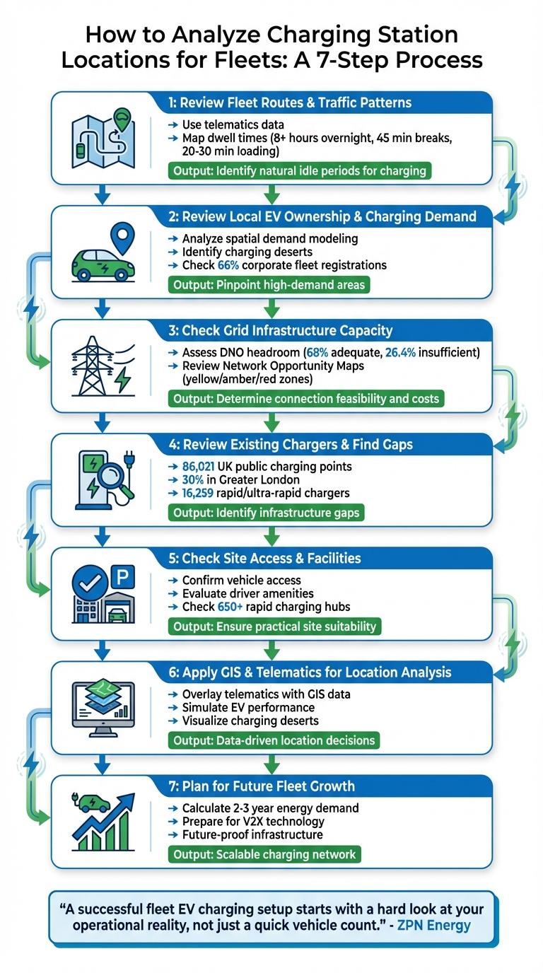
7-Step Process for Analyzing Fleet EV Charging Station Locations
How to Find Profitable EV Charger Locations (Step-by-Step)
Step 1: Review Fleet Routes and Traffic Patterns
The first step in selecting the ideal charging locations is figuring out where your vehicles travel and when they remain idle. Telematics data provides a detailed look at average and maximum daily distances, specific route paths, and energy consumption patterns. By using this data, you can track road usage and identify dwell times. This insight is key to understanding your fleet's routes and idle periods, which will help shape your charging strategy. Once you have this information, map your routes to visualise these critical idle moments.
Map Your Route Coverage
Begin by focusing on your fleet's busiest routes and key operational hubs. Telematics systems record every journey, offering valuable insights into travel patterns. The aim is to find spots where vehicles naturally remain stationary long enough to charge: for example, 8+ hours overnight at a depot, 45 minutes during a lunch break, or 20–30 minutes while loading or unloading. Aligning charging with these natural downtimes ensures minimal disruption to operations.
"By mapping out these dwell periods, you can align your charging infrastructure with your natural operational workflow. This minimises disruption and ensures that charging happens when vehicles are already idle." - ZPN Admin
For predictable urban routes under 100 miles, centralised overnight AC charging at your depot may be all you need. However, longer or more variable routes could require DC rapid chargers at your base or access to public charging points along the way. Before making any decisions, overlay your telematics data and scheduling information onto your current diesel routes to identify how they align with potential charging networks.
Check Traffic Flow and Congestion
Once you’ve mapped routes and dwell times, examine local traffic patterns to refine your site choices. Traffic conditions can significantly impact how easily your drivers can access charging points at different times of the day. Aggregated mobile network data can help identify origin-destination flows and high-demand hotspots along your routes. This ensures you avoid placing chargers in areas prone to congestion during peak hours.
Shift patterns also play a role in determining charging needs. Fleets operating around the clock will need rapid charging between shifts, whereas single-shift fleets are better suited to overnight depot charging. Seasonal demand is another factor - your infrastructure needs to handle peak delivery periods, not just average days. Placing chargers on the outskirts of urban areas, such as park-and-ride locations, can help manage traffic flow while providing convenient access to charging points.
Step 2: Review Local EV Ownership and Charging Demand
After analysing routes and idle times, it's essential to dive into local EV trends. This ensures your charging infrastructure meets the needs of both your fleet and the wider public. By understanding where EV adoption is growing and how charging patterns are evolving, you can avoid overloading certain areas or investing in chargers where demand is minimal. This step helps pinpoint the locations where charging access is most critical.
Find High-Demand Areas
It's not just about where EVs are registered - it’s about where they’re actually being used. Interestingly, 66% of new EV registrations stem from corporate fleets, but registration data often fails to reflect true operating locations. Instead, focus on data that shows where vehicles are actively in use.
Spatial demand modelling is a powerful tool for this. It integrates datasets like traffic flow, census data, points of interest, and current charger usage to identify areas that need infrastructure. For example, in 2022, Oxfordshire County Council teamed up with Mind Foundry to use machine learning for predicting EV infrastructure needs. This platform combined geospatial modelling with live and historical data, helping the council visualise demand and grid constraints. The result? Better funding applications and more precise site selections.
Another consideration is residential areas with limited off-street parking, often referred to as "charging deserts". If your fleet operates in these regions, competition for public chargers can become a challenge - unless you establish dedicated depot facilities. Tools like Zapmap, which maps 95% of UK public chargepoints and provides live availability for 70% of them, can help identify gaps in coverage.
Balance Fleet and Public Charging Requirements
Your charging strategy should strike a balance between your fleet's predictable needs and the fluctuating demand from public users. This approach helps you avoid duplicating existing infrastructure and reduces reliance on public chargers during peak times.
Take inspiration from the City of York Council’s three-tier strategy. They combined slow AC chargers at park-and-ride locations with ultra-rapid hubs in central areas. This approach not only eased urban congestion but also catered to a diverse range of charging needs. Such a system allows different user groups to access charging without overwhelming specific sites.
For fleet managers, telematics data can be invaluable. Analyse your vehicles’ dwell times and compare them with public charging patterns in the same areas. If your fleet needs charging during peak public usage, investing in dedicated depot infrastructure becomes crucial. On the other hand, if your routes align with underused public chargers, integrated payment solutions and fleet fuel cards can give your vehicles access to existing networks - eliminating the need for additional private infrastructure.
Step 3: Check Grid Infrastructure Capacity
Understanding the capacity of the local grid is crucial to ensure your charging infrastructure can meet both current and future needs without triggering expensive upgrades.
Once you've mapped routes and dwell times, it's time to evaluate the grid's capacity. The critical factor here is "headroom" - the available, unused capacity at nearby substations. A study of Scottish primary substations for HGV charging infrastructure revealed that 68% had enough headroom to support high-demand charging scenarios, where vehicles arrive in concentrated peaks. However, 26.4% lacked sufficient headroom, even for low-intensity charging setups. This highlights why early grid assessment is so important.
To assist with this, Distribution Network Operators (DNOs) provide Network Opportunity Maps. These maps use colour coding to indicate the connection potential at various substations:
- Yellow zones: Adequate headroom for high-intensity charging.
- Amber zones: Limited capacity, suitable only for low-intensity charging.
- Red zones: Require upgrades before any charging infrastructure can be installed.
These maps are an excellent starting point for evaluating connection feasibility.
Understand Connection Costs
The cost of connecting to the grid depends on the existing capacity at your chosen location. For example:
- Installing a fast charger (7.3kW) typically costs between £1,000 and £3,000 and takes around 8–12 weeks to connect.
- A standard 1,000kVA distribution transformer can support up to 135 fast chargers (7.3kW) or 20 rapid chargers (50kW).
If your site needs more than this capacity, you could face significant infrastructure investments, which makes early planning even more critical.
Compare Current and Future Grid Capacity
When assessing grid capacity, consider both your immediate requirements and potential future expansion. The table below summarises the grid demands of different charger types:
| Charge Point Type | Power Output | Current Capacity Required | Future-Proofing Capacity | Typical Connection Cost |
|---|---|---|---|---|
| Fast AC | 7kW | Generally not required | 3-phase AC; 80A per phase | £1,000–£3,000 |
| Fast AC | 22kW | 3-phase AC; 32A per phase | N/A | £1,000–£3,000 |
| Rapid DC | 50kW | 3-phase AC; 100A per phase | 3-phase AC; 100A per phase | £3,500–£10,000 |
| Supercharger DC | 130kW | 3-phase AC; 200A per phase | 3-phase AC; 200A per phase | £70,000–£120,000+ |
Engage Early with Your DNO
Reach out to your local DNO as early as possible - ideally before finalising a site. Many DNOs offer "connection surgeries", where you can explore costs and capacity options without needing to submit a formal application. When you're ready to apply, provide detailed technical specifications for your chosen charge point models. This helps the DNO assess factors like harmonic emissions and earthing requirements, ensuring your infrastructure operates safely and efficiently.
If you're considering multiple sites, rank them by priority. This allows the DNO to guide you towards locations with the best spare capacity and the most cost-effective connection options. Early collaboration with your DNO can save you time, money, and headaches in the long run.
Step 4: Review Existing Chargers and Find Gaps
After analysing grid capacity, the next step is to map out the existing chargers and align them with your fleet's needs. This ensures that the charging infrastructure is adequate for your operations. By late 2025, the UK had 86,021 public charging points spread across 43,507 locations. However, the distribution is highly uneven - over 30% of these chargepoints are located in Greater London alone. This imbalance leaves many areas underserved, potentially affecting fleet efficiency.
To identify gaps, overlay your fleet's route data onto maps of the existing charging infrastructure. Telematics can help pinpoint where vehicles naturally stop, such as during 20–30 minute loading periods or 45-minute lunch breaks. Check if rapid chargers are available in these locations. If drivers frequently stop in areas with no nearby charging facilities, you've found a gap that needs to be addressed.
Tools like Zapmap Insights, which cover 95% of UK chargepoints, can help assess gaps in the network. Integrating this data into Geographic Information Systems (GIS) allows you to visualise how well the existing infrastructure aligns with your fleet's routes. For example, a 2023 collaboration between Field Dynamics and Zapmap used spatial analysis to identify "on-street households" without a public charger within a five-minute walk, enabling local authorities to pinpoint specific gaps. Such data-driven insights are invaluable for evaluating whether current chargers meet your operational needs.
Compare Chargers by Location Type
Once you've identified gaps, categorise the existing chargers by location type to determine their suitability for your operations. For instance, rapid chargers at motorway services are ideal for long-haul routes, while slower AC chargers at retail parks are better suited for extended stops. This classification helps you decide if the current infrastructure meets your needs or if dedicated fleet chargers are necessary.
The UK currently has 16,259 rapid and ultra-rapid chargers, accounting for about 60% of public charging capacity. However, these are mostly concentrated along motorways, leaving rural and suburban areas lacking. If your vehicles require a 30-minute charge but only slower chargers are available at key stopping points, this highlights a gap in the infrastructure.
Locate Areas with Limited Charging
Telematics can also help distinguish between routes that can rely on depot charging and those that need public chargers. For example, short urban routes with predictable schedules may only require overnight charging at your depot. In contrast, long-distance or unpredictable journeys will demand access to rapid public chargers along the way. Identify "dead zones" where vehicles frequently travel but lack nearby suitable charging options.
Before committing to new charging sites, use Distribution Network Operator (DNO) data to confirm whether the grid in underserved areas can support additional chargers. The UK government estimates that at least 300,000 public chargepoints will be needed by 2030. Planning ahead is crucial to ensure your fleet remains operational as demand for charging infrastructure grows.
Step 5: Check Site Access and Facilities
Once you've identified gaps in the grid and charger availability, the next step is to evaluate whether potential locations are practical for your fleet. While mapping out possible sites, you also need to ensure they can physically accommodate larger vehicles. Things like road width, obstacles, and entry points play a huge role in ensuring vans or heavy goods vehicles can move safely and efficiently. Before committing to a site, it’s crucial to inspect for any restricted access points or physical barriers that could pose a problem.
A great example of effective site planning is the City of York Council's HyperHubs. These hubs are located at park-and-ride facilities and combine ultra-rapid charging with on-site solar power generation and battery storage, offering a smart solution for fleets.
Confirm Easy Access for Fleet Vehicles
Your fleet vehicles need to enter, park, charge, and exit smoothly. This is especially critical for larger vans and HGVs. Make sure there’s enough parking space, clear visibility, and room for vehicles to manoeuvre, even during busy periods. Restricted access points, like narrow entrances or low clearances, should be carefully checked. Good lighting and robust security measures are also key, particularly for drivers working early mornings or late nights.
If rapid charging hubs are part of your plan, focus on locations with six or more high-speed chargers. These hubs are ideal for high-demand fleets like long-haul logistics or taxi services. The UK now has over 650 such hubs, which are designed to handle multiple vehicles at once, cutting down on wait times and keeping fleets running efficiently.
Once you’re confident that vehicles can easily access the site, it’s time to think about the additional amenities that can make a difference for your drivers.
Review Available Facilities
Charging isn’t just about plugging in vehicles - it’s also about making sure drivers are comfortable and productive during the process. For example, drivers using DC rapid chargers often need 20–60 minutes to charge up to 80% capacity. During this time, access to restrooms, food, and waiting areas is essential. Align charging stops with natural breaks, like a 45-minute lunch or a 20–30 minute loading window at a distribution centre.
"Consumers want chargepoints to be where they need them and for them to be easily accessible." - Geospatial Commission
When evaluating potential sites, think about locations that integrate with other services or transport options. Charging hubs at motorway services or retail parks often provide the amenities drivers need without requiring extra travel. This keeps your fleet moving efficiently while ensuring drivers have access to everything they need during their charging stops.
Step 6: Apply GIS and Telematics for Location Analysis
Now it's time to use data-driven tools to refine your location strategy. Geographic Information Systems (GIS) and telematics replace guesswork with solid evidence, helping you pinpoint where your fleet operates, where charging gaps exist, and where future demand might arise. These insights naturally build on your earlier work analysing routes and grid capacity.
Use Telematics Data
Telematics provides real-time vehicle data, offering a clear picture of your fleet's daily operations. It tracks average and maximum distances, route patterns, and dwell times - those moments when vehicles are stationary and available for charging. For instance, if telematics shows a 45-minute lunch break, that could be the perfect spot for a DC rapid charger. It also highlights factors affecting efficiency, ensuring charging infrastructure can handle peak demand. By aligning operational data with infrastructure needs, telematics strengthens your charging location decisions.
"A successful fleet EV charging setup starts with a hard look at your operational reality, not just a quick vehicle count." - ZPN Energy
In 2022, the Geospatial Commission supported Dynamon in creating the "ZERO" tool. This tool combined fleet telematics with external datasets, revealing that large UK fleets drive 4.9 million kilometres daily - mileage that could shift to zero-emission vehicles with the right infrastructure. GRS Fleet Telematics offers advanced tracking solutions to help fleet managers pinpoint exactly where and when charging support is needed.
Apply GIS for Location Mapping
GIS complements telematics by integrating operational data with local infrastructure insights. It overlays telematics data with external factors like grid capacity, population density, and points of interest, creating a comprehensive view of where charging makes the most sense. This analysis identifies "charging deserts" (areas with little or no coverage) and high-demand zones where your fleet operates most often. Together, GIS and telematics enable a strategic, forward-thinking approach to building a reliable charging network.
Fleet managers can visualise vehicle routes alongside maps of existing chargers, grid capacity, and land ownership to pinpoint optimal locations for new infrastructure.
"Location data is key to building the right infrastructure in the right places, giving confidence to the EV owners of today and tomorrow that they can efficiently reach their destination." - Baroness Neville-Rolfe, Minister of State, Cabinet Office
GIS also allows you to simulate how EVs would perform on routes currently used by diesel vehicles. By creating virtual models of your operations, you can test different scenarios - like placing rapid chargers at motorway services versus overnight AC chargers at depots - before committing to specific hardware.
Step 7: Plan for Future Fleet Growth
Once you've assessed your routes, grid capacity, and charging infrastructure gaps, it's time to think ahead. Your charging setup shouldn't just cater to today's fleet but must be ready to handle tomorrow's demands. As you transition from diesel to electric vehicles and expand your fleet, your energy needs will rise substantially. Accurate forecasting, based on solid data, is crucial.
Plan for Fleet Expansion
To estimate future energy demand, start by calculating the projected number of vehicles you'll have in the next 2–3 years. Multiply this by their average mileage, then divide by their efficiency (measured in miles per kWh). For peak power demand, multiply the number of vehicles likely to charge simultaneously by the kW rating of each charger. Compare this figure to your site's Maximum Import Capacity (MIC). If your expected load exceeds the MIC, you'll need to explore grid upgrades or alternative solutions like battery storage .
Grid upgrades through your local Distribution Network Operator (DNO) can take over a year and cost hundreds of thousands of pounds, so it’s wise to reach out to them early . To save on future costs, consider future-proofing your site during initial installations. For example, laying oversized ducting and additional cabling during the first round of excavation can prevent expensive re-digging later . Use telematics data to pinpoint when expansion becomes necessary. Advanced telematics systems, like those from GRS Fleet Telematics (https://grsft.com), can provide valuable insights into operational performance and help you align infrastructure upgrades with actual needs .
Prepare for New Charging Technology
Charging technology is evolving quickly. Today’s ultra-rapid chargers can deliver over 300 kW, and bidirectional charging (known as vehicle-to-everything or V2X) is on the horizon. This technology will allow EVs to return power to the grid or buildings during peak demand periods. When choosing charging equipment, opt for modular designs that are easy to service and upgrade. Also, ensure all hardware supports the Open Charge Point Protocol (OCPP), which allows for greater flexibility as your network grows .
Match charging speeds to your operations. AC chargers (7 kW–22 kW) are ideal for overnight depot charging, while DC rapid chargers (50 kW+) work better for quick turnarounds but require more grid capacity and higher upfront investment. A mix of both types can provide the flexibility needed as your fleet diversifies. You can also pair ultra-fast chargers with on-site solar panels and Battery Energy Storage Systems (BESS) to manage costs and reduce reliance on the grid.
"ChargePoint's next generation of EV chargers will be revolutionary, not evolutionary. The architecture underpinning them enables highly anticipated technologies which will deliver a significantly better experience for station owners and the EV drivers." - Hossein Kazemi, Chief Technical Officer of Hardware, ChargePoint
Using Telematics Data for Better Decisions
Telematics turns charging location analysis into a precise, data-driven process. Instead of guessing where your fleet might need charging, managers can gain a clear understanding of vehicle routes, idle times, and energy usage. As ZPN Admin aptly puts it: "A successful fleet EV charging setup starts with a hard look at your operational reality, not just a quick vehicle count.". This approach underscores the importance of using telematics to refine your charging strategy with actionable insights.
By expanding on earlier route analysis, advanced tracking systems provide in-depth operational data. Take GRS Fleet Telematics (https://grsft.com), for example. It offers detailed data that complements prior route mapping and grid assessments. It tracks key metrics like average and maximum daily distances, helping you calculate total energy demand in kilowatt-hours (kWh). Additionally, it identifies dwell times, which can guide your choice of chargers. For instance, if your vans typically park for over 8 hours overnight, AC chargers may be a cost-effective option. On the other hand, regular 45-minute stops might call for DC rapid chargers to keep your fleet moving efficiently.
Telematics also sheds light on your fleet's peak power usage, a crucial factor in assessing grid capacity. This insight builds on earlier grid capacity evaluations, ensuring your energy supply aligns with demand. To estimate energy needs, you can divide the total daily miles by the average efficiency (miles per kWh) and then multiply this by the number of vehicles charging simultaneously.
Mileage patterns in daily operations play a significant role in charging decisions. For example, short urban delivery routes may require a different strategy compared to longer trips, even if the total distances are similar. Additionally, carrying heavy payloads can lower efficiency, further influencing energy requirements.
Modern telematics systems offer even more benefits by integrating with dynamic load management software. These systems can monitor electricity prices in half-hour intervals, allowing you to schedule charging during off-peak times. This not only helps optimise energy use but also reduces overall operating costs.
Conclusion: Putting Your Location Plan into Action
Selecting the best charging station locations for your fleet involves turning a mix of data into a practical strategy. Begin by using telematics to estimate your total daily energy demand (kWh) and peak power draw (kW). For example, if you have 20 vans using 7kW chargers, you'll need a capacity of 140kW. Compare this figure with your site's Maximum Import Capacity (MIC), as provided by your local Distribution Network Operator (DNO), to identify any potential shortfalls early on.
Once you’ve assessed your demand, think about how the placement of infrastructure impacts both costs and functionality. Position chargers near existing power sources to save on installation costs. If your site's capacity is limited, consider using smart charging software or Energy Management Systems to manage loads dynamically, enabling more chargers to operate efficiently with the available supply. You could also explore options like Battery Energy Storage Systems (BESS) or solar PV to provide backup power during outages and cut peak-time electricity costs.
Engaging with your DNO early is essential, as grid assessments and potential upgrades can require significant time and investment. Once these steps are complete, consolidate everything into a clear, actionable plan.
GRS Fleet Telematics (https://grsft.com) offers the operational insights needed to support this data-driven process. Starting at just £7.99 per month, their tracking tools let you monitor dwell times, route patterns, and energy consumption, helping you choose the right charger types and locations. This ensures you avoid over-provisioning while building an infrastructure tailored to your fleet's actual needs.
FAQs
How can telematics data help optimise charging station locations for fleets?
Telematics data gives fleet managers a clear view of vehicle usage, making it easier to decide where charging stations should go. By studying GPS data, trip patterns, dwell times, and energy consumption, you can identify the most travelled routes and stops where vehicles linger - perfect spots for chargers. Combining this information with vehicle range and energy requirements helps strike the right balance between slow and rapid chargers, avoiding overspending or insufficient coverage.
Modern telematics tools take it a step further with predictive analytics. They can forecast charging demand, recommend cost-saving schedules for off-peak charging, and track vehicle battery levels in real time. These features enable you to build a charging network that reduces downtime, lowers energy costs, and supports fleet expansion by ensuring new chargers are placed where they’re needed most.
With GRS Fleet Telematics, you can create a charging infrastructure that fits your fleet’s actual needs, keeping vehicles running smoothly and making the most of your investment.
What should fleet managers consider when assessing grid capacity for charging stations?
When planning grid capacity for charging stations, several factors come into play to ensure everything runs smoothly and efficiently. Start by examining the local electricity distribution capacity. This means looking at the expected peak power demand and checking if nearby substations can handle it.
You’ll also need to consider any limitations or potential upgrades required by the Distribution Network Operator (DNO). These factors could influence both the timeline and the cost of your installation. If the grid can’t meet your needs, options like load management solutions or infrastructure upgrades might be necessary to keep your fleet powered up.
By planning ahead and working closely with local energy providers, you can make smarter decisions about where to place charging stations, minimise downtime, and ensure your setup can handle future fleet growth.
How can GIS tools help identify the best charging locations for fleet vehicles?
GIS tools play a crucial role for fleet managers aiming to pinpoint the best locations for charging stations. By combining vehicle tracking data - such as routes, dwell times, and usage patterns - with external factors like existing infrastructure, grid capacity, and parking availability, GIS generates detailed heatmaps and drive-time analyses. These insights reveal high-demand areas and uncover coverage gaps, ensuring charging stations are strategically placed where they’re most needed.
On top of that, GIS software can evaluate potential sites by assigning suitability scores. These scores take into account key factors like proximity to depots, daily mileage, power supply availability, and planning restrictions. This method allows fleet managers to prioritise locations that reduce downtime and improve cost efficiency. Leveraging high-resolution telematics data from GRS Fleet Telematics further refines this process, ensuring site selection is based on actual vehicle usage patterns and supports operational targets specific to the UK.